⭐ Features
We offer many features to help you get started with your indoor mapping project. Below is a list of features that we offer. If you have any questions or need help with a feature please contact us.
We also offer a list of MODULES 📦 and FEATURES that can be added to your project.
Compare Cloud and Enterprise Features
| Feature | Cloud Hosting Standard | Cloud Hosting Enterprise | On Premise Enterprise |
|---|---|---|---|
| Campus Plan Visualization | ✔️ | ✔️ | ✔️ |
| Barrier Free | ✔️ | ✔️ | ✔️ |
| Where am I QR Code | ✔️ | ✔️ | ✔️ |
| POI Management | ✔️ | ✔️ | ✔️ |
| Routing Wayfinding | ✔️ | ✔️ | ✔️ |
| PDF Map Download | ✔️ | ✔️ | ✔️ |
| Image Map Download (PNG) | ✔️ | ✔️ | ✔️ |
| Sharing, QR, Links, everything | ✔️ | ✔️ | ✔️ |
| Search | ✔️ | ✔️ | ✔️ |
| Internationalization EN, DE | ✔️ | ✔️ | ✔️ |
| Progress Web App, responsive | ✔️ | ✔️ | ✔️ |
| Desktop, Mobile, Tablet, Kiosk | ✔️ | ✔️ | ✔️ |
| Invoice Billing | ✔️ | ✔️ | ✔️ |
| REST API | ❌ | ✔️ | ✔️ |
| Custom Search + API Integration | ❌ | ✔️ | ✔️ |
| ACAD Pipelines Connect to CAFM | ❌ | ✔️ | ✔️ |
| Single Sign On (SSO) | ❌ | ✔️ | ✔️ |
| Custom Domain | ❌ | ✔️ | ✔️ |
| Custom Map Design | ❌ | ✔️ | ✔️ |
| Web Analytics | ❌ | ✔️ | ✔️ |
| Bookway Library Routing | ❌ | optional | optional |
| Self Hosting On Premise | ❌ | ❌ | ✔️ |
Online Presentation

Modules 📦
📐 ACAD Pipelines Connect to CAFM
- Automated sync to your CAFM system Autodesk, Allplan
- No need to change your workflow or process
- Work with .dwg or .dxf files
- No need to manage multiple systems
- Single source of truth, your CAFM system
🌐 Custom Domain
Enterprise customers can use their own domain name yourdomain.com for the indoor map. This allows you to show true integration into your brand.
🎨 Custom Map Design
If our map styles are not your thing then this is your option. We can style the map as you like with your color scheme. Simply ask us to take you through the steps of styling your map.
🔑 Single Sign On (SSO)
Enterprise Single Sign On (SSO) is a feature that allows users to log in once and access multiple applications without being prompted to log in again. We support the following SSO providers: SAML2, OAuth2, OpenID Connect, LDAP, Active Directory, and many more.
🔍 Custom Search + API Integration
Connect to your content management system (CMS) and deliver enhanced location search options. Upon connecting to your CMS we can now display this information on an indoor map. Using our API we can connect your application data to a location on the indoor map and have it searchable such as:
- People
- Departments
- Lecture Halls
- Events
- Facilities
⚙️ API connect more
- Room booking systems
- Facility management systems
- Kiosk management systems
- Digital signage systems
Interoperability is a top priority and indrz is capable of integrating with any system due to its bottom up approach and architecture. Options / Modules All of our options and modules allow you to cherry pick what you would like to provide your users.
📚 Bookway Library Routing
Bookway Route your users directly to any book location, any floor, any shelf anywhere on campus. Hyper local routing allows us to provide links to any book location dynamically from your search portal. As a user searches for a book they are provided with a link to the exact location of their book search results. Manage bookshelves and book locations with our online portal and remove the need to work with Excel.
Features ⭐
🗺️ Campus Plan Visualization
A truely digital campus map that is interactive and easy to use. The map is displaying your data. Each campus, building, floor, space or POI is displayed in a digital format.
♿ Barrier Free
Manage your barrier free entrances and exits. Check indoor routes for wheelchair access.
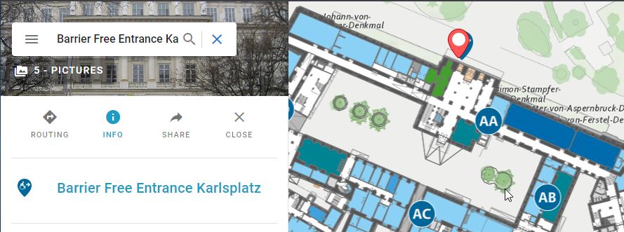 TU Vienna Barrierfrei Entrance (click image to see live map)
- Connect images of each entrance
- Image gallery of each POI
- Attach details to the POI about the entrance
🔍 Where am I QR Code
Print a QR code and place it in your building. When scanned the user will be taken to the map and shown where they are. 
📍 POI (Point of Interest) Management
Manage any POI and share them across your systems. We provide an easy interface to create, edit, and delete POIs. The POI can be linked to any room, building, campus, route, person, lecture or event. POIs can be anything from a vending machine, bench, plant, door or socket. POIs can be linked to any other POI or route on the map.
- Connect images of each POI
- Image gallery of each POI
- Attach details to the POI
- Self ordering of POI tree menu
🧭 Routing Wayfinding
A very important feature to allow users to find their way from A to B within your buildings. We build a network of ways inside your building data so you can route a user from any location to any location on any floor or building. Routes are calculated on the fly for maximum flexibility. Here is a list of some routing features: a. Barrier free routes (wheelchair routes) b. Mid points along routes c. Route to nearest bus station d. Route from building entrance e. Route from /to nearest train station f. Shortest path
🖨️ PDF Map Download
With a single click you can download a PDF of the map showing you the exact area you are looking at. The PDF is generated on the fly and can be printed or saved for later use.
- PDF customization
- logo, copyright
- Title, Sub Title
📷 Map Image Download
Download the map as an image. This is useful for presentations or to use in your own documents.
📍 Indoor Maps + Orientation
We build the final map using our standard map styles and designs providing an awesome “look and feel” with our many years of cartographic experience.
🔗 Sharing contents
The ability to share routes, waypoints or points of interest is done with simple links. These links can be placed in emails, skype chats or integrated in your homepage.
🔍 Search
A standard search is provided out of the box. You are able to search the following objects:
- Building name
- Room number and name (if provided during import)
- POI points (if provided during import)
🌍 Internationalization
Language support is built in for multiple languages. Currently the application supports the following languages. Feel free to help translate into your own language, translators are welcome.
- English
- German
⚙️ API
The API is a RESTful API that allows you to access all the data in the system. The API is built to deliver GeoJSON as standard output or JSON.
Here is an example of a GeoJSON POI feature:
// Example of a GeoJSON POI Feature
    {
      "id": 12791,
      "type": "Feature",
      "geometry": {
        "type": "MultiPoint",
        "coordinates": [
          [
            1821984.228611699,
            6139541.623002973
          ]
        ]
      },
      "properties": {
        "icon": "/media/poi_icons/g2249.png",
        "images": null,
        "name": "Public Transport",
        "name_en": "Public Transport",
        "name_de": "Öffentliche Verkehrsmittel",
        "floor_num": 0,
        "floor_name": "EG",
        "description": "",
        "enabled": true,
        "poi_tags": null,
        "html_content": null,
        "html_content_de": null,
        "floor": 1,
        "campus": 1,
        "category": 26,
        "id": 12791,
        "src_icon": "poi"
      }
    }
📈 Web Analytics
Keep your data your own and use your own analytics tool. We provide a simple way to connect to Matomo, Google Analytics or any other analytics tool you use.
📱 Responsive Mobile, Desktop
No app store, all web. The system will run on any device big or small on a html viewer. We guarantee the application will run under the newest browsers and there versions
- Chrome
- Microsoft Edge
- Firefox
- Safari
Detailed Feature List
| Feature | Description |
|---|---|
| Campus Plan Visualization | Digital campus map displaying data interactively. Multiple locations |
| Barrier Free | Manage barrier-free entrances and exits, including wheelchair access routes. |
| Where am I QR Code | QR codes to show users their location on the map. |
| POI (Point of Interest) Management | Manage POIs with images, galleries, and details, html. |
| Routing Wayfinding | Route users from any location to any location within buildings, including barrier-free routes. |
| PDF or Image Map Download | Download maps as PDFs or images for presentations or documents. |
| Indoor Maps + Orientation | Final maps with standard styles and designs for indoor orientation. |
| Sharing contents | Share routes, waypoints, or POIs with simple links. |
| Search | Search buildings, rooms, and POIs. |
| Internationalization | Support for multiple languages, including English and German. |
| API | RESTful API to access system data in GeoJSON or JSON format. |
| Web Analytics | Connect to analytics tools like Matomo or Google Analytics. |
| Responsive Mobile, Desktop | Runs on any device with a modern browser, no app store required. |
| Share | Share routes, maps, maps with POI's, or POIs with simple links. |
| Create QR Codes to Share | Download QR codes to share routes, maps, maps with POI's, or POIs. |
| Admin Interface | Manage users, roles, permissions, and data. |